“Cause out on the edge of darkness, there rides a peace train.
Oh peace train take this country, come take me home again.”
Cat Stevens, Peace Train
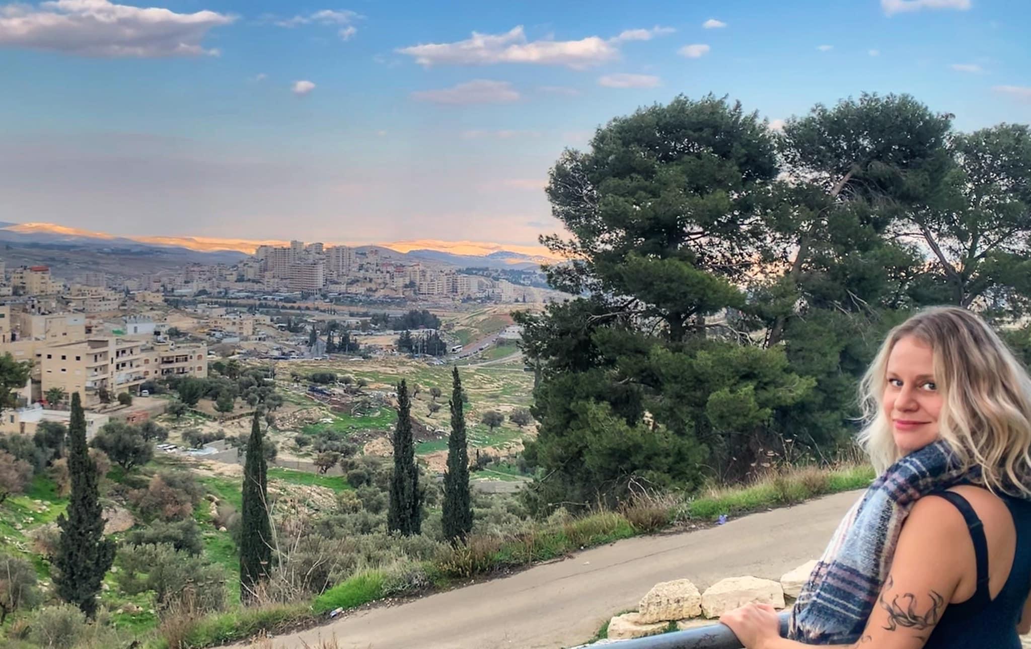
Completed in 2011, the Jerusalem Light Rail unites east and west Jerusalem. This how a light rail should be – small, light, and frequent, on a traffic free Jaffa Road. It links the Jewish suburbs of west and northeast Jerusalem with the Arab suburbs of the north and east of the Old City. The featured picture shows two trains passing at Jaffa Central, underneath a neat mural that shows one weaving down Jaffa Road through vignettes of Israeli urban life. Their destinations are shown sequentially in three languages. Synchronicity determined that in the picture, both were in Arabic.
It was controversial when first mooted, and extreme elements on both sides of the conflict opposed any such normalization of relations between the Jewish and the Arab communities. There were demonstrations in European countries against the “line that divided a city”, but these petered out when polls showed that Arabs in East Jerusalem found the line to be a blessing. It got dad to work on time; it got mom to the cornucopia that is the Mahane Yehuda fresh food markets, just four stops from the Damascus Gate; and it delivered the kids to school and back safely and punctually. It is said, with some justification, that earlier attacks on the line were perpetrated by thugs incited by Fatah, the political wing of the Palestinian Authority, which is alleged to control the taxi industry of East Jerusalem.
During the recent unrest, the line was often blocked and trains attacked during demonstrations and street fighting, but service was resumed quicksmart. Arab passengers were at times abused by Jews, and stations were the targets of random rammings by cars and heavy vehicles – the so-called “siyarah intifada” – with many Jewish casualties and “neutralized” perpetrators.
If you’ve ever ridden the light rail in Jerusalem, then you’ve seen the section with the chairs that go down when you sit on them – each has a wheelchair sign because people in wheelchairs get priority there since there’s space, but if you’re a mom and you’ve got a stroller, you can sit there, too, and that’s where these two women are sitting: I watched them both get in, one wore a hijab and the other wore a sheitel, and they both had their arms and leg covered, and no collarbone, no sir, and I watched the struggle through the crowd on the light rail with their strollers, big and blue and bulky, match match.
They each took a seat on opposite sides of the row where the wheelchairs go, and they put their strollers in the middle. Each woman stared straight ahead out the window as Jeursalem went by in one long smear, looking straight past each other.
Strangers on a light rail, with their matching strollers, but by accident, their strollers faced each other, and the kids met eye to eye — both bundled up in winter coats and hats and shoes, both brown eyed babes with pink cheeks, and curly hair, well fed and well loved, and they could have been brothers. And while their mothers stared straight ahead watching Jerusalem blur by, the two boys smiled at one another, and chatted back and forth as only little babies can, but as everybody should.
But calm appears to have descended, and folk of good will on all sides of the literal and figurative line pass in peace through Arab and Jewish Jerusalem.
“I believe that one fine day all the children of Abraham
Will lay down their swords forever in Jerusalem”
Steve Earl, Jerusalem
Light Rail Mural, Jaffa Road
Facebook Postscript from Sarah Tuttle-Singer, 20th February 2023
If you’ve ever ridden the light rail in Jerusalem, then you’ve seen the section with the chairs that go down when you sit on them – each has a wheelchair sign because people in wheelchairs get priority there since there’s space, but if you’re a mom and you’ve got a stroller, you can sit there, too, and that’s where these two women are sitting: I watched them both get in, one wore a hijab and the other wore a sheitel, and they both had their arms and leg covered, and no collarbone, no sir, and I watched the struggle through the crowd on the light rail with their strollers, big and blue and bulky, match match.
They each took a seat on opposite sides of the row where the wheelchairs go, and they put their strollers in the middle. Each woman stared straight ahead out the window as Jeursalem went by in one long smear, looking straight past each other.
Strangers on a light rail, with their matching strollers, but by accident, their strollers faced each other, and the kids met eye to eye — both bundled up in winter coats and hats and shoes, both brown eyed babes with pink cheeks, and curly hair, well fed and well loved, and they could have been brothers. And while their mothers stared straight ahead watching Jerusalem blur by, the two boys smiled at one another, and chatted back and forth as only little babies can, but as everybody should.
Like Lord Byron, he was mad, bad, and dangerous to know. He may or may not have been a psychopath – he killed his way to the top, murdering his relatives, and also, his wife Mariamne, whom loved truly, madly, deeply – but he suspected her of plotting to depose him, so she had to go too. He regretted it instantly and embalmed her in honey so he could spend quality time with her by her open catafalque.
Herod did a lot of questionable things, but he has gone down in Christian demonology for an atrocity he did NOT commit – he didn’t massacre the Innocents to ensure that baby Jesus would not live to supplant himself as King of the Jews! The slaughter of the babies was an invention of later Christian propagandists. Also, he was not the Herod who’s daughter Salome invented lap dancing and in payment, demanded the head of John the Baptist. Nor was he the Herod who told the imprisoned Jesus “I’m the King of the Jews!” That was Andrew Lloyd Webber’s camp caricature. Herod was a common name amongst the later (and last) Hasmoneans.
To his Jewish subjects, he was not a Kosher King, being only half Jewish, and then, only through this dad (even today, opinions about him are mixed for the same reason). Accordingly, he felt that he had to prove himself, like similarly half-Jewish, and much wiser King Solomon. So he built things. And man! Could he build! His stuff was not large – it was Monumental.
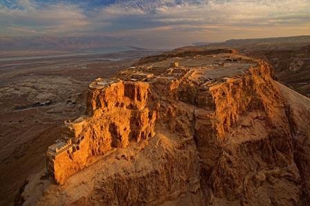
At Caesarea, on the Mediterranean coast, he build a port, a seaside palace and a city. In Jericho, another magnificent palace. At Herodium, he built a fortress-palace-mausoleum, but first, he built a hill high enough that he could see Jerusalem from the summit. Across the River Jordan, in present day Jordan, he rebuilt a fortress-palace at Machaerus which was said to be location of the imprisonment and execution of John the Baptist, and the venue for Salome’s notorious dance, The ancient town of Sebastia, on a hill with panoramic views across the West Bank, is another location of Herodian brickage; its Nabi Yahya Mosque is said to be the burial site of the Baptist – although his head is believed to rest in an ornate catafalque in Damascus’s splendid Umayyad Mosque. And he a fortress and summer palace on the Masada massif overlooking the Dead Sea, and the site of one of history’s most famous “last stands”.
He obviously liked palaces. When he died – and he died horribly as befits a bad boy – he was laid to rest in a bespoke tomb in his Herodium eyrie.
But his crowning glory was his breathtaking refurbishment of the Second Temple, rendering it a wonder of the contemporary world. Too bad that a “wabble of woudy webels”, to quote Bickus Dickus in “The Life of Brian”, had to rise up against Rome in 66CE, precipitating the destruction of Jerusalem, the death of thousands, and the razing of temple to the ground. All that impressive Herodian brickage was sent crashing to the ground, and all that remains is the Kotel, the hallowed Western or Wailing Wall.
(The featured image shows signature Herodian ashlar blocks in the Kotel, the Western or “Wailing” Wall)
Apart from building things, was Herod really that “great”? I reckon he gave himself that soubriquet – or else the Romans did, probably in sardonic irony (which Herod, narcissistic and paranoid, probably didn’t get). His subjects didn’t think so and were happy when he died. Some accounts suggest that he’d ordered his bodyguard to slaughter the heads of prominent Hebrew families on the event of his death so that the people would not feel like rejoicing when he passed.
Herodian brickage thrown down by the Romans
Herodium
Masada
The largest house brick in the world. The Western Stone of the Kotel 13.6m
One of the pleasures of moving to the Australian bush and living in Bellingen Shire is discovering its often overlooked history. This is the story of Twin Pines. Not as dippy as Twin Peaks, nor as sinister as Wayward Pines, it is a story of ordinary people doing extraordinary things.
When I first came to this land,
I was not a wealthy man,
So I built myself a shack,
And I did what I could.
I called my shack
Break My Back,
But the land was sweet and good,
And I did what I could.
When I first came to this land,
I was not a wealthy man.
So I built myself a farm.
I did what I could.
Prologue
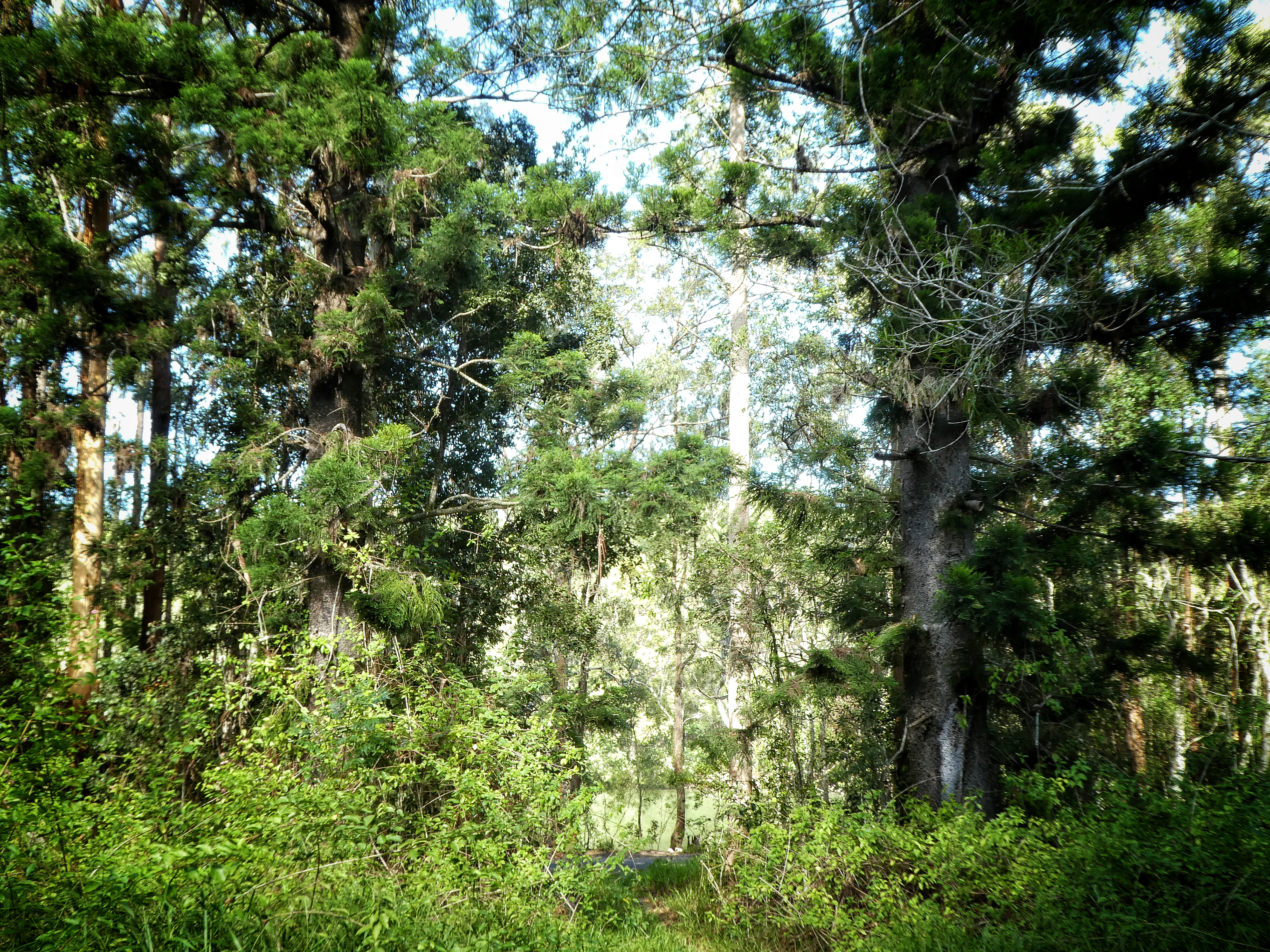
We in Bellingen Shire , some ten kilometers west of the seaside town of Urunga on the mid north coast of New South Wales. The Tarkeeth Forest lies between the Bellinger and Kalang Rivers, and these are connected tidally to the ocean at Urunga – the only place in Australia where two rivers meet the ocean together. The forest rises from the rivers on either side of the Fernmount Range, the easternmost extension of the Great Dividing Range that spans the eastern edge of our island continent. Above and between the two rivers, it is a rain-harvesting, filtration and stabilization ecosystem vital to the waterways and wetlands around them, and is a habitat for bird, reptilian, mammalian and marsupial wildlife, including koalas, wallabies, echidnas, quolls, goannas, owls, fruit doves and cockatoos. The east-west Fernmount Range Trail is an ancient highway called the Yildaan Dreaming Track. It led from the plains beyond the Dorrigo massif to what is now the seaside town of Urunga, known then to the Gumbaynggirr people as a “place of plenty”. The first people would descend the spurs on the north and south flanks of the range to fishing and ceremonies on the riverside. The Tarkeeth Forest therefore contains areas of significant indigenous culture, recalling song lines and stories of the Dreamtime, places of ceremony, of birth and burial, and of atrocity.
The Fells of Twin Pines
Exploring the history of the forest, I chanced across Lloyd Fell’s story of the Fell Family Farm. This was located close to the present Twin Pines Trail, just east of Fells Road on South Arm Road, and west of the new bridge across the Kalang. It’s a great story of how the road got its name, and of how, in the late 19th century, Moses Lacey, the first selector, ran a store on the river bank. How back then, there was no road along the river, the South Arm (of the Bellinger), and access to farms along the river was by small jetties. South Arm Road was built to serve a quarry, now disused, just west of the present Fell’s Road.
Lloyd tells the story of how in 1926, New Zealand farmer, solo-yachtsman, and returned ANZAC Chris Fell first saw the land that became the family farm, purchasing it from Moses’s deceased estate for a thousand pounds. Chris was impressed by the two mature pines that stood on either side of the track leading to a rough timber house that already stood there – and these gave the farm its name. He cleared the bush, felling and hauling timber (helped by his neighbour Bennett’s bullock team) until he had sufficient land and capital to run cattle. In time, he built up a prosperous dairy business and cattle stud, and he and his wife Laura, a Sydneysider from a well-to-do Vaucluse family, raised their three children there. It was a hard life on the land back then – one of dedication, hard work, and perseverance. Power did not come to the South Arm until 1959. Many in the Shire still remember Chris and Laura and indeed, went to school with Lloyd, Bill and Margaret. When the kids were young, they went to the small Tarkeeth school house located just west of the present Fells Road junction. There are quite a few folk who remember attending the little school before its closure in 1972. Indeed, since I published the story on a local FaceBook page, and a former pupil published a picture of the Tarkeeth School’s “Class of ’68”, old aquaintances and school chums have reconnected with each other. Here is the History of Tarkeeth School. It can be obtained from Bellingen Museum,
Twin Pines is no more. When Chris could no longer work the farm, Bill took over the business. In 1966, with changes in the dairy industry rendering to business unprofitable, he sold it to the Errington family.They sold it shortly afterwards to Australian Paper Mills who in the early ’80s, sold it to State Forests – now the Forestry Corporation. APM cleared the land and established a flooded gum plantation thereon and on adjacent blocks – today’s Tarkeeth State Forest. That plantation is now being aggressively harvested – clear felled, actually – a matter of considerable concern to us locals and to many in the Shire. in the South, the forest comes right down to the Kalang River, and this too is a cause for concern as the harvesting and reforestation operations involve clearfelling, burning and spraying with herbicide. The consequences of an extreme weather event could be dire.
The farm house was not demolished. When the plantation was established, but was destroyed by fire years later. The school was sold to an Erik Johannsen who lived there for many years with a collection of animals. Tragically, he ended his own life after setting fire to the school. Fells Road puts the family name on the map, and whilst the Errintons did not linger here long, they are remembered in Erringtons Trail, a well-maintained forest track linking South Arm Road to the Fernmount Range Trail and thence the Bellinger Valley. Bennett the bullocky has a trail named for him too. Walking through the Forest Corp plantation, you can still just make out the place where the house stood. There is an old dam in the heart of the bush where tomatoes were once grown. In the the forest, amongst the plantation trees and native regrowth, you will come upon large, old angophera, grey gum, bloodwood and black butt habitat trees, their broad, spreading branches indicating that these once grew in open pasture.
The pines are still there, some ten metres in from South Arm Road. They are not on what is now the Twin Pines Trail, but at the beginning of a trail just to the east of it. A pair of big and beautiful hoop pines. And next to one of them, an old gate post, a dumb signpost to a a vanished past. Furthermore, they have had loads of babies. There are small hoop pines close to their parents, and eastwards along the road towards the new bridge over the Kalang. Nature never sleeps.
Hoop pines at Twin Pines, Tarkeeth
Nothing remains of the Fells farm except some old fence posts, but standing there, it is easy to imagine what it would have been like in those days. But one thing has not changed. Walk into the bush halfway between the pines and Eastern Trail, you will see what Chris Fells discovered back in the ‘thirties:
“Down on the left as you looked out of the house, there was an especially thick, almost impenetrable circle of bush surrounding a small lagoon. Within this, was a haven for all kinds of wildlife such as bandicoots, native possums, snakes, frogs, and and a great assortment of birds: parrots, kingfishers, kookaburras, currawongs, black ducks, bowerbirds, honey-eaters, and by the water itself, the beautiful egrets, ibis and spoonbills. If you peep into the lagoon from the road, its great white paperbark trees, knee-deep in thick green water, gave it an air of mystery and magic”.
And indeed, as the photographs below show, the Tarkeeth Lagoon is still quite special. Folk who grew up on South Arm Road and explored the area as children, still remember the mystery of the place. Those animals and birds still live in the Tarkeeth, but the tall paperbarks have long since fallen and lie as moss and epiphyte-covered sculptures beside the water.
Read the full story of Twin Pines here in Lloyd Fell’s small but captivating book:
Local historian John Lean’s new book “Settlers of South Bellingen and the Lower South Arm”, his “Settlers of the Upper South Arm and Spicketts Creek”, and also, “The History Of Tarkeeth Public School” are available at the Bellingen and Urunga museums.
For other posts in our Small Stories series of ordinary folk doing extraordinary things, see: The schools of the Tarkeeth, another tale from our neck of the woods; TheOdyssey of Assid Corban, the story of a Lebanese migrant to New Zealand, and The Monarch of the Sea, the rollicking tale of an unlikely “pirate king”. There is also No Bull!a true though somewhat overwrought local saga of battling bovines – set in Bonville, not far north of us.
Chris Fell – The ANZAC Story
A century ago, on 31st October 1917, the Australian Light Horse charged the Turkish trenches during the Battle of Beersheba in one of history’s last great cavalry charges. The 31 light horsemen who fell are buried in the Beersheba War Cemetery along with 116 British and New Zealand soldiers who perished in the Beersheba battle. There are 1,241 graves in the military cemetery, soldiers being brought in from other Great War Middle East battlefields. It is a tranquil, poignant, and beautiful place in the Negev Desert, where the bodies of young men from Australia and New Zealand and from the shires of England, Ireland, Scotland and Wales were laid to rest. “Lest we forget”.
In his ebook The Twin Pines Story, Lloyd Fell tells how his father served as a mounted machine gunner with the New Zealand forces in the Gaza ampaign of late 1917. His war record reports that he was one of the machine gunners who fought through the day before the famous charge to knock out the Turkish machine guns on the strategic al Saba Hill east of Beersheba. Had these fortifications not been overrun, the Light Horse would have been prevented from advancing on the wells. Afterwards, the machine gunners and their Kiwi mates took part in a bayonet charge against the enemy.
As Jean Bou wrote in The Weekend Australian:
“The New Zealand brigade was sent against Tel el Saba, but this steep-sided hill with terraced entrenchments was formidable. The dismounted horsemen, with the limited fire support of their machine-gunners and the attached horse artillery batteries, had to slowly suppress the enemy defences and edge their way forward. Chauvel sent light horse to assist, but as the afternoon crawled on, success remained elusive. Eventually the weight of fire kept the defenders’ heads down enough that the New Zealanders were able to make a final assault. The hill was taken and the eastern approach to Beersheba opened, but nightfall was approaching.
See: http://specialreports.theaustralian.com.au/888793/a-remarkable-feat-of-arms/
Beersheba War Cemetery, Israel
This post opened with that great troubadour Pete Seeger singing Oscar Brand’s celebrated pioneer song. I conclude with his rendering of David Mallet’s tribute to the simple life.
Inch by inch, row by row,
Gonna make this garden grow.
Gonna mulch it deep and low,
Gonna make it fertile ground.
Pullin’ weeds and pickin’ stones,
We are made of dreams and bones
Need spot to call my own
Cause the time is close at hand
We have been visiting Bellingen Shire for the last thirty years, and moved a house onto our bush block over twenty years ago. Bellingen, the Bellinger Valley on the Mid North Coast of New South Wales, is well known as a picturesque, well-preserved (founded in 1870) country town. In former times, it was the centre of a thriving dairy and timber industry, and more recently, as a popular tourist spot between the university city of Armidale and the country music capital of Tamworth to the west, and the Pacific “holiday coast” of Coffs Harbour, Sawtell, Urunga, and Nambucca Heads, to the east, with their sand, surf and sun.
Between the two is the Great Dividing Range, the rolling, high country escarpment of the New England Plateau with its gorges and waterfalls, and the world-heritage Dorrigo National Park with it timeless, untouched rainforests – a “land that time forgot”. And linking them all, the old trunk road, aptly if touristically named Waterfall Way.
Bellingen is popular for its cafes and coffee shops, craft industries and shops, music festivals, and federation facades. It’s visual appeal, and it’s bucolic rural environs have seen the town used on many occasions as a film location. In the seventies, it was a Mecca for young people seeking an alternative lifestyle. The hills thereabout are still scattered with cooperatives and communes, or, in local council-speak, multiple occupancies. In the old days, no love was lost between the “hippies” and the farmers and loggers, and politics were dominated by the rural, conservative “born to rule” National and Country Party. Nowadays, it’s heir, the National Party still dominates the political scene, but its clear majorities decrease fractionally election by election, and by the turn of the century, there may no longer be a National Party member. But demographics do change, as does society. The hippies’ children and the farmers’ kids grew up together, attended the high school together, played, partied, and paired together, and now, there are grand children and great grandchildren.
As the timber and dairy industry has declined, Bellingen’s economy has changed. Once exclusively agrarian – including a time as one of the prime producers of cannabis sativa – tourism now plays a vital role. Bellingen advertises itself to visitors and to present and future residents as a clean, green and sustainable shire. Nature’s wonderland, from its golden beaches to its mountain rainforests and waterfalls. A Tourist Heaven with a cornucopia of recreational activities for young and old – from lazy bathing and picnicking to energetic rambling and trecking, camping and climbing, canoeing and fishing. A cultural mecca with many cafes, live music, craft and artisan shops, and music and writers’ festivals.
Two years ago, the online magazine Traveller published a breathless paean to “the bohemian town that is heaven on earth’. Happy traveller Sheriden Rhodes wrote: Some places are so beautiful; it feels like holy ground. For me, Bellingen has always had that consecrated feeling. It’s obvious, given the name the early pioneers gave the Promised Land, a scenic 10 minute-drive from Bellingen’s township itself. Here the land is so abundantly verdant and fruitful; it literally drips with milk and honey. It’s a place so special the fortunate locals that call it home, including its most famous residents George Negus and David Helfgott would much rather keep all to themselves”.
This is the marketing spin hyped up by the council, the chamber of commerce, and real estate and B&B interests. The reality is somewhat different. Bellingen and the “Holiday Coast” generally have seen a large influx of city folk seeking a different lifestyle for themselves and their children, and also of retirees seeking rural or seaside tranquility – in such numbers that Coffs Harbour and its seaside satellites have become in many ways the Costa Geriatrica.
Many newcomers are not fully aware that the Coffs Coast generally is one of the poorest areas of rural New South Wales. Statistics for youth unemployment and senior poverty are among the highest in the state with all the attendant economic, social and psychological impacts as evidenced by high rates of depression, domestic violence and substance abuse. Health and transport services outside the urban centres are pretty poor. Rising property values and high rents price low-income families and singles out of the market. Decreasing profit margins have forced many of those attractive cafes and coffee shops to close.
Nor is the clean, green, sustainable shire as picture perfect as the brochures portray It. There is environmental degradation with clear-felling and land-clearing, and flammable, monoculture, woodchip-bound eucalyptus plantations that encircle Bellingen – a potential fire bomb primed to explode during one of our scorching, hot dry summers. There is generational degradation of the Bellinger’s banks and the graveling up of its once deep depths. And there the encroachment and expansion of water-hungry, pesticide and herbicide reliant blueberry farms,
But on the right side of the ledger, we in the Shire are indeed blessed by Mother Nature. The coastline boasts magnicent headlands and promontories, and long, pristine and often deserted beaches. The World Heritage Gondwana rainforests are a national treasure, and surrounding national parks truly are a natural wonderland. We never tire of the drive from Urunga to Armidale via Waterfall Way, as it crosses the Great Dividing Range and the New England Plateau. The Kalang River as it flows beside South Arm Road and between the Tarkeeth and Newry State Forests is itself one of the Shire’s hidden and largely unvisited secrets, a haven for fishermen, canoeist and all who love mucking about in boats.
Compared to many places on this planet, we’ve really not much to complain about …